Saudi Arabia Volcanoes
-
Harrat Khaybar
-
Harrat Rahat
-
Harrat Ash Shaam
-
Harrat Lunayyir
-
Harrat Ash Shaam
-
Harrat Rahat
-
Harrat Ash Shaam
-

Harrat Khaybar
-
Harrat Lunayyir
-
Harrat Ash Shaam
-
Harrat Rahat
-
Harrat Khaybar
-
Harrat Ithnayn
-
Harrat Ithnayn
-
Harrat Ithnayn
-
Harrat Ash Shaam
-
Harrat Lunayyir
-
Harrat Ithnayn
-
Harrat Kishb
-
Harrat Lunayyir
Saudi Arabia has 8 Holocene volcanoes. Note that as a scientific organization we provide these listings for informational purposes only, with no international legal or policy implications. Volcanoes will be included on this list if they are within the boundaries of a country, on a shared boundary or area, in a remote territory, or within a maritime Exclusive Economic Zone. Bolded volcanoes have erupted within the past 20 years. Suggestions and data updates are always welcome ().
| Volcano Name | Location | Last Eruption | Primary Volcano Type |
|---|---|---|---|
| Harrat Ash Shaam | Syria-Jordan-Saudi Arabia | 2670 BCE | Volcanic field |
| Harrat al Birk | Southwest Saudi Arabia | Unknown - Evidence Credible | Volcanic field |
| Harrat Ithnayn | Northwest Saudi Arabia | Unknown - Evidence Credible | Volcanic field |
| Harrat Khaybar | Northwest Saudi Arabia | 650 CE | Volcanic field |
| Harrat Kishb | West-Central Saudi Arabia | Unknown - Evidence Credible | Volcanic field |
| Harrat Lunayyir | Northwest Saudi Arabia | 1000 CE | Volcanic field |
| Harrat Rahat | Saudi Arabia | 1256 CE | Volcanic field |
| Jabal Yar | Saudi Arabia | 1810 CE | Volcanic field |
Chronological listing of known Holocene eruptions (confirmed or uncertain) from volcanoes in Saudi Arabia. Bolded eruptions indicate continuing activity.
| Volcano Name | Start Date | Stop Date | Certainty | VEI | Evidence |
|---|---|---|---|---|---|
| Jabal Yar | 1810 ± 10 years | Unknown | Confirmed | 2 | Observations: Reported |
| Harrat Rahat | [1292] | [Unknown] | Uncertain | ||
| Harrat Rahat | 1256 Jun 5 | 1256 Jul 27 (?) | Confirmed | 3 | Observations: Reported |
| Harrat Lunayyir | 1000 (in or before) | Unknown | Confirmed | Observations: Reported | |
| Harrat Khaybar | 0650 ± 50 years | Unknown | Confirmed | 2 | Observations: Reported |
| Harrat Rahat | 0641 | Unknown | Confirmed | 2 | Observations: Reported |
| Harrat ar Rahah-'Uwayrid | [0640 (?)] | [Unknown] | Uncertain | ||
| Harrat Ash Shaam | 2670 BCE ± 200 years | Unknown | Confirmed | Isotopic: 14C (calibrated) |
Saudi Arabia has 4 Pleistocene volcanoes. Note that as a scientific organization we provide these listings for informational purposes only, with no international legal or policy implications. Volcanoes will be included on this list if they are within the boundaries of a country, on a shared boundary or area, in a remote territory, or within a maritime Exclusive Economic Zone. Suggestions and data updates are always welcome ().
| Volcano Name | Location | Primary Volcano Type |
|---|---|---|
| Jabal Baqarah | Middle East (southern) | Cone |
| Jibal al Haylah | Middle East (southern) | Cone |
| Harrat Hutaymah | Middle East (southern) | Volcanic field |
| Harrat ar Rahah-'Uwayrid | Middle East (southern) | Volcanic field |
There are 22 photos available for volcanoes in Saudi Arabia.
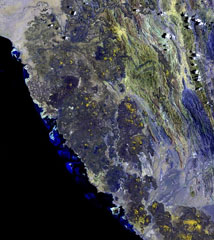
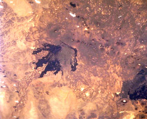
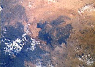 The 4,000 km2 Harrat Ithnayn volcanic field appears in the center of this Space Shuttle image with north to the upper right. Harrat Ithnayn contains scattered shield volcanoes and scoria cones that have produced extensive lava flows, some of which are less than 4,500 years old. Harrat Ithnayn merges with the larger Harrat Khaybar volcanic field to its south, the dark partially cloud-covered area at the lower left.
NASA Space Shuttle image STS-61A-483-20 (http://eol.jsc.nasa.gov/).
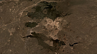 The central area of the 14,000 km2 Harrat Khaybar volcanic field is shown in this December 2020 Planet Labs satellite image monthly mosaic (N is at the top; this image is approximately 49 km across). This area contains tuff rings and maars from phreatomagmatic activity and scoria cones, with some more recent lava flows. The larger light-colored crater near the center is Jabal Bayda, and the cone that produced the black lava flows to the north is Jabal Qidr.
Satellite image courtesy of Planet Labs Inc., 2020 (https://www.planet.com/).
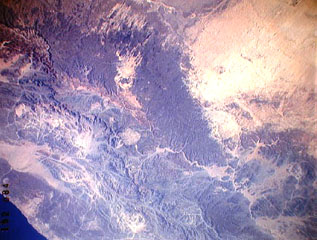 The large dark wedge-shaped area near the center of this Space Shuttle image is Harrat 'Uwayrid, a major volcanic field in NW Saudi Arabia that contains basaltic scoria and tuff cones. Bedouin legends say that Hala-'l-Bedr erupted fire and stones in 640 CE, killing herdsmen and their cattle and sheep. Another volcanic field, Harrat ar Rahah (top-left), lies to the NW.
NASA Space Shuttle image STS37-152-84, 1991 (http://eol.jsc.nasa.gov/).
 The dark-colored lava flows in this NASA International Space Station image (N to the left) lie at the south end of the Es Safa volcanic field. This basaltic field (also referred to as As Safa), lies SE of the capital city of Damascas (Dimashq) and contains at least 38 scoria cones. This volcanic field lies within the northern part of the massive alkaline Harrat Ash Shaam volcanic field that extends from southern Syria to Saudi Arabia.
NASA International Space Station image ISS007-E-8414, 2003 (http://eol.jsc.nasa.gov/).
 Harrat Khaybar, one of Saudi Arabia's largest volcanic fields, covers an area of more than 14,000 km2 to the N of Madinah (Medina). This Space Shuttle image shows the central vent area of the volcanic field. Light-colored areas at the center of the image show lava domes and tuff rings; above this area is Jabal Qidr volcano. The lava flows extending to the W from the central vent area are young prehistoric and historic. An eruption was reported in early Mohammedan times during the 7th century CE.
NASA Space Shuttle image STS38-74-6, 1990 (http://eol.jsc.nasa.gov/).
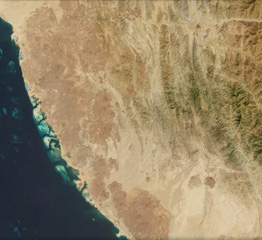
 The 1,800 km2 Miocene and Quaternary Harrat al Birk volcanic field extends diagonally across the center of this NASA Landsat image along the Red Sea coast. Dark-colored areas are lava fields and yellowish areas mark scoria cones and deposits. Scoria cones occur throughout the field, and a few outlying cones lie E of the main lava field.
 NASA Landsat image, 2003 (USGS).
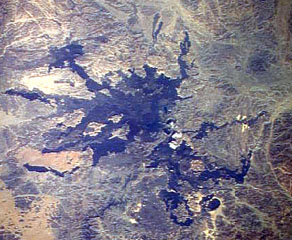
 The Golan Heights basaltic volcanic field lies NE of Lake Tiberius (Sea of Galilee) in the Anti-Lebanon Mountains of SW Syria near the borders with Lebanon and Israel. Lake Tiberius, whose surface lies below sea level, is at the upper left in this NASA Space Shuttle image (N is to the upper right). The volcanic field contains 56 scoria cones of Pliocene-to-Holocene age and includes the prehistoric cone of Majdel Shams in the Golan Heights.
NASA Space Shuttle image STS060-97-24, 1994 (http://eol.jsc.nasa.gov/).
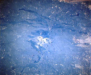
 Lava flows radiate down desert valleys away from the center of Harrat Lunayyir, a basaltic volcanic field in NW Saudi Arabia, east of the Red Sea port of Umm Lajj. Harrat Lunayyir contains about 50 volcanic cones that were constructed along a N-S axis. Harrat Lunayyir is one of the smallest of the Holocene lava fields of Saudi Arabia, but individual flow lobes extend up to about 30 km from the center of the Harrat. One of the cones may have erupted around the 10th century CE or earlier.
NASA Space Shuttle image STS26-41-61, 1988 (http://eol.jsc.nasa.gov/).
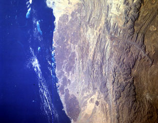 The Harrat al Birk volcanic field forms the dark-colored area between the Red Sea coast and the center of this NASA Space Shuttle image (N to the upper right). This 1,800 km2 Miocene and Quaternary volcanic field separates the Tihamat ash Sham and Tihamat 'Asir coastal plains. Scoria cones occur throughout the field and a few outlying cones lie E of the main lava field.
NASA Space Shuttle image STS055-151-184, 1993 (http://eol.jsc.nasa.gov/).
 Around 200 identified scoria cones have formed throughout the 1,800 km2 Harrat al Birk volcanic field, seen along the Red Sea coast of Saudi Arabia in this 20 October 2020 Sentinel-2 satellite image (N is at the top; this image is approximately 93 km across). In the center of the top boundary of this image is two recent cones and lava flows, Jabal Ba’a and Jabal al Qishr, in the Asir mountains.
Satellite image courtesy of Copernicus Sentinel Data, 2019.
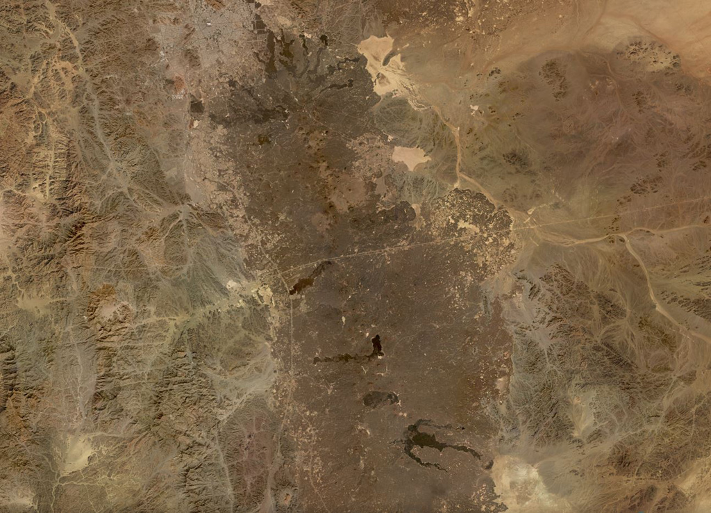
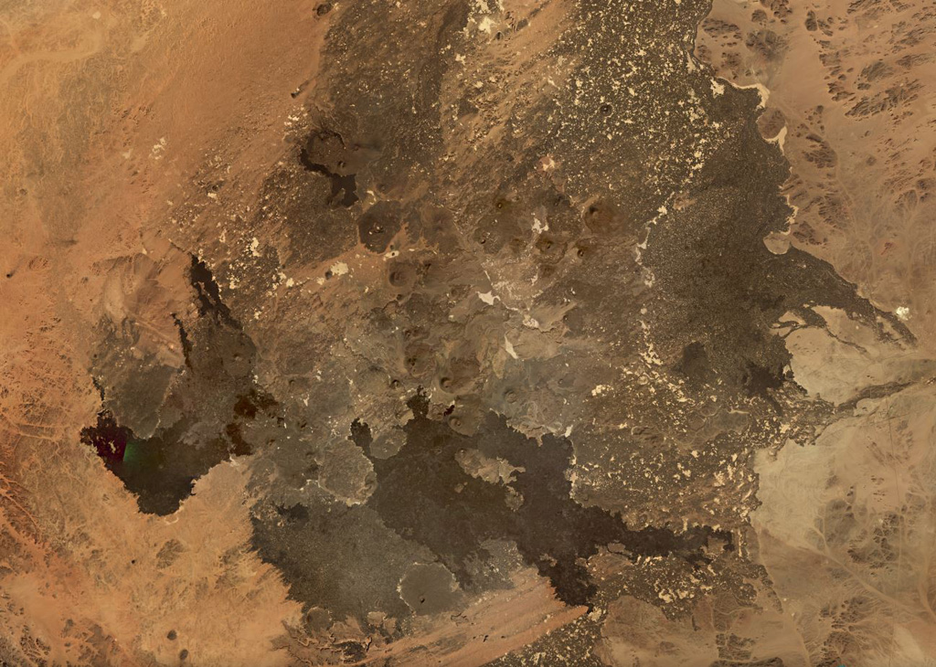
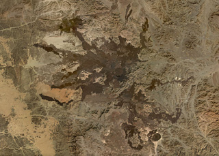
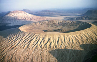
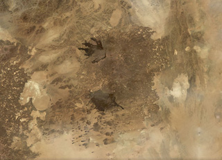 The roughly 6,000 km2 Harrat Kishb volcanic field is shown in this November 2019 Planet Labs satellite image monthly mosaic (N is at the top; this image is approximately 180 km across). The field is comprised of scoria cones, tuff rings, maars, lava domes, and flows. Along the western edge of the lower black lava flow field is the Al Wahbah maar, one of the largest in the Arabian Peninsula at 2.3 km wide.
Satellite image courtesy of Planet Labs Inc., 2019 (https://www.planet.com/).
 Two scoria cones of the Jabal Yar volcanic center in SW Saudi Arabia are sown in this December 2019 Planet Labs satellite image monthly mosaic (N is at the top; this image is approximately 19 km across). There are three groups of cones and this is the northernmost 'Ukwatain group. Both cones underwent flank collapse or rafting during their eruptions and now open towards the W. Lava flow boundaries are visible on the western side of both cones.
Satellite image courtesy of Planet Labs Inc., 2019 (https://www.planet.com/).
 The Harrat Lunayyir volcanic field contains around 50 identified craters with numerous lava flows seen in this November 2019 Planet Labs satellite image monthly mosaic (N is at the top; this image is approximately 89 km across). The scoria cones contain summit craters and many experienced flank collapse or rafting during the eruptions, resulting in horseshoe-shaped craters. The youngest lavas occur in the central part of the field and cover 25 km2.
Satellite image courtesy of Planet Labs Inc., 2019 (https://www.planet.com/).
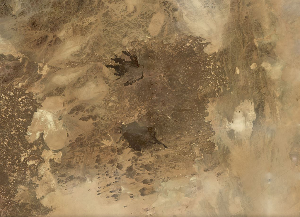
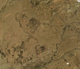
 The NW part of the 5,900 km2 Harrat Kishb volcanic field is seen in this Space Shuttle image. The field is located E of a N-S-trending line of volcanic fields in central Saudi Arabia. The medium-brown-colored Jabal Aslaj scoria cone visible near the top of the dark lava flows near the center of the image was the source of the flows seen here. A second area of young flows seen at the lower right surrounds the circular Al Wahbah maar. These lava flows are stratigraphically younger than a 6,500-4,000-year-old pluvial period.
NASA Space Shuttle image STS102-708-13, 2001 (http://eol.jsc.nasa.gov/).
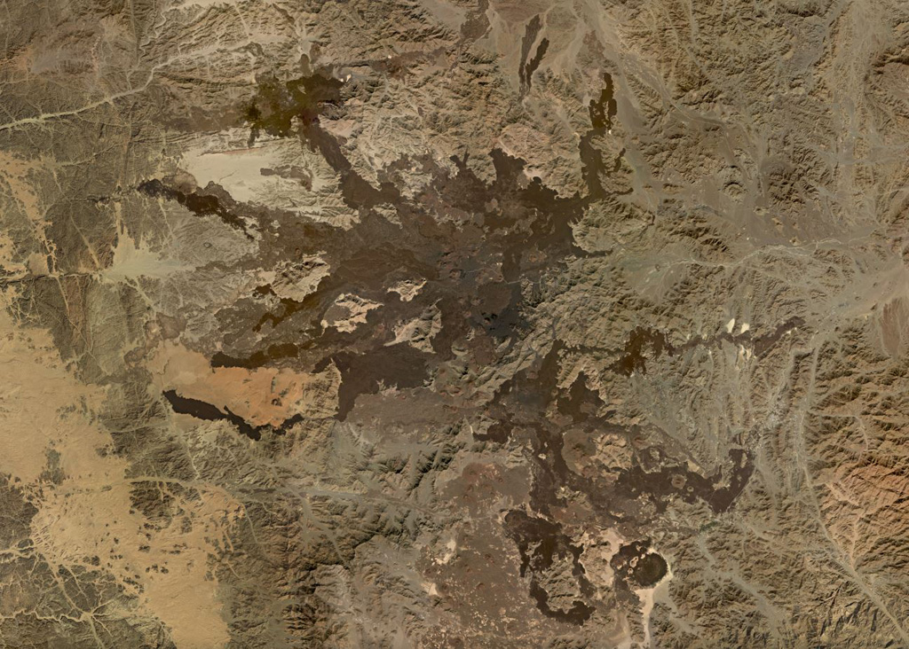
 The 100,000 km2 Harrat Ash Shaam volcanic field extends from the NW corner to the SE corner of this February 2021 Planet Labs satellite image monthly mosaic (N is at the top; this image is approximately 480 km across). The Harrat contains several volcanic fields including Al Harrah, Jabal ad Druze, Es Safa, Golan Heights, and the Kra Lava Field.
Satellite image courtesy of Planet Labs Inc., 2021 (https://www.planet.com/).
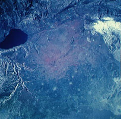
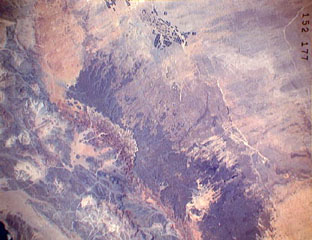 The darker-colored area extending diagonally down the center of this Space Shuttle image is Harrat ar Rahah, the northernmost of a series of Quaternary volcanic fields paralleling the Red Sea coast of Saudi Arabia. The geometrical outlines of the historical town of Tabuk (top center), located on the road leading from Hijr to Damascus, can be seen to the N. There are fewer young volcanoes in Harrat ar Rahah than in other harrats (lava fields) to the S.
NASA Space Shuttle image STS37-152-177, 1991 (http://eol.jsc.nasa.gov/).
 The northern part of the 20,000 km2 Harrat Rahat volcanic field, the largest in Saudia Arabia at 50-75 km wide and ~300 km long, is shown in this November 2019 Planet Labs satellite image monthly mosaic (N is at the top; this image is approximately 192 km across). Earlier work identified 986 vents across the field. Recent lava flows in the northern end encroach on the city of Al-Madinah.
Satellite image courtesy of Planet Labs Inc., 2019 (https://www.planet.com/).
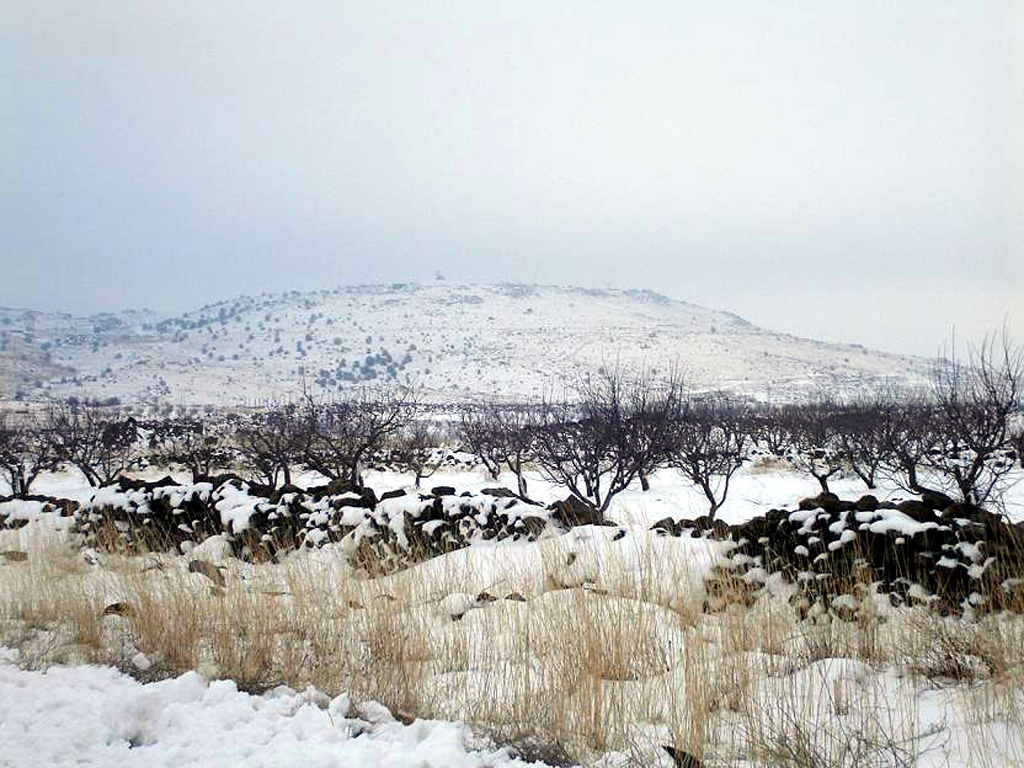
 Snow-capped Tell Qeni is the highest point of the Jabal ad Druze volcanic field, the southernmost in Syria. It lies in the Haurun-Druze Plateau in SW Syria near the border with Jordan. The field consists of a group of 118 basaltic volcanoes active from the lower-Pleistocene to the Holocene.
Anonymous photo by Wikipedia user KFZI310, 2006.
 Harrat ar Rahah-'Uwayrid is the northernmost of a series of Quaternary volcanic fields paralleling the Red Sea coast of Saudi Arabia, south of the city of Tabuk. The olivine basaltic field extends NW-SE about 240 km overall, and contains numerous scoria cones, tuff cones, and associated lava fields.
Satellite image courtesy of Planet Labs Inc., 2020 (https://www.planet.com/).
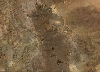
 The 4,000 km2 Harrat Ithnayn volcanic field covers much of this November 2019 Planet Labs satellite image monthly mosaic (N is at the top; this image is approximately 94 km across). Scoria cones are visible across the field, with the Jabal Hazam Khadra’ cone is at the bottom of the center of the image. The lava flows are different shades dependending on variable amounts of weathering, erosion, and the amount of sedimentation on the surface.
Satellite image courtesy of Planet Labs Inc., 2019 (https://www.planet.com/).
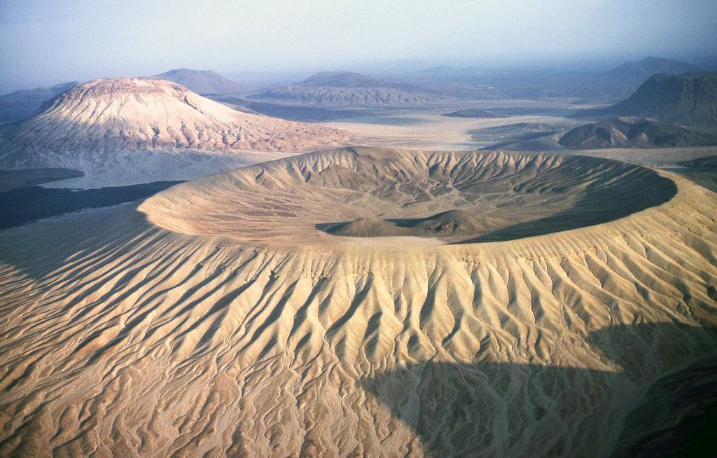
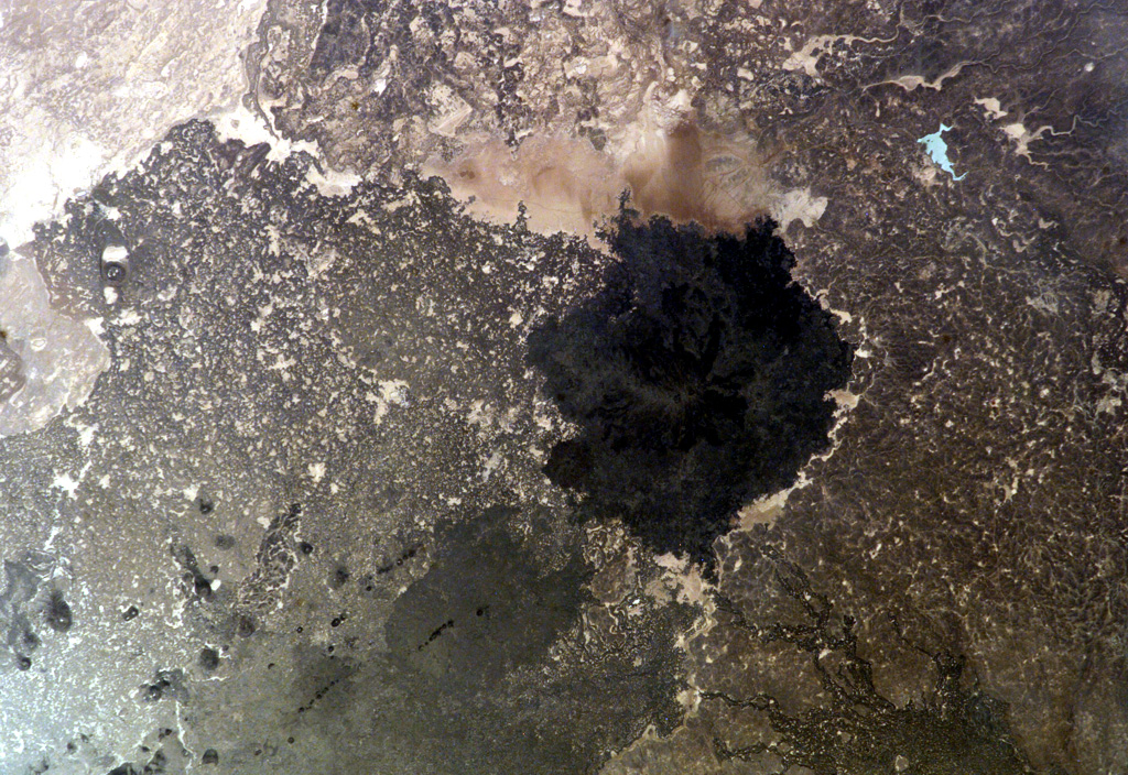
 Light-colored lapilli deposits mantle the Jabal Bayda ("White Mountain") tuff cone; a lava dome is visible within the crater. Jabal Bayda and the Jabal Abyad lava dome (upper left) are part of the 14,000 km2 Harrat Khaybar volcanic field, located N of the city of Madinah (Medina). A 100-km-long N-S linear vent system in Harrat Khaybar contains lava domes, tuff rings, the Jabal Qidr stratovolcano, and numerous small basaltic cones.
Copyrighted photo by Michael Fenton, USGS (courtesy Earth Science World Image Bank http://www.earthscienceworld.org/images)
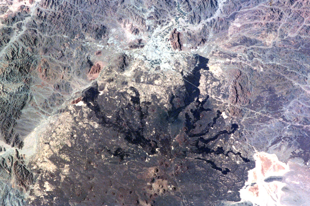
 The northern part of Saudi Arabia's largest lava field, 20,000 km2 Harrat Rahat, is seen in this NASA International Space Station image (N to the top left). Harrat Rahat extends for 300 km S of the city of Madinah (Medina), the light-colored area at the top-center. Although basaltic scoria cones are more common, small shield volcanoes and lava domes are also present. The most well-known eruption took place in 1256 CE, when the large dark-colored flow seen extending to the upper right traveled 23 km to within 4 km of Madinah.
NASA International Space Station image ISS001-344-27, 2001 (http://eol.jsc.nasa.gov/).
This is a compilation of Saudi Arabia volcano information sources, such as official monitoring or other government agencies.
| Volcano Observatories | |
|---|---|
| Saudi Geological Survey | |
| Volcanic Ash Advisory Center | |
|---|---|
| Toulouse Volcanic Ash Advisory Center (VAAC) Notices and Archive | |